I set off early Friday after my clients were finished with. I'd expected rain . . . and we got a lot overnight, but the day was turning out glorious. Since rain is predicted for this weekend, it was time to get some nude hiking in. Again, nothing spectacular planned . . . just figured a go for a trailhead, strip and go hiking.
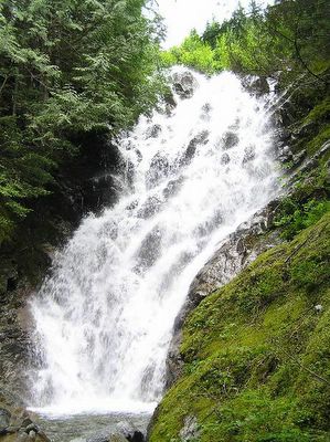
A few days ago I'd come across this photograph of Scenic Creek Falls taken some years ago, and the author had indicated that the photo was taken below the BPA corridor. It was a great shot but it looked like nothing I expected from Scenic Creek. I didn't expect any falls . . . much less a large one . . . down near the Surprise Creek Trailhead. So I decided to go exploring.
I parked just short of the trailhead were there is another gravel road leading up in the general direction of the creek. Figured that was the best place to start. Well, I figured wrong, as usual. It was a BPA Access Road in terrible disrepair. I had to stop and slip into my aquasocks within 50 feet . . . because I had to cross the frigid ankle deep water of the creek right off. I took this opportunity to slip off my shorts as well, now that I was out of sight of the trailhead and the half dozen people hanging about there.
The road continued up over the BPA easement and into the tree line above. I still didn't have an inkling of where it was leading except I'd never been this route before. I wondered if it was the elusive back route up into the Scenic Hot Springs property.
But that wasn't to be. The road soon turned down and ended at a BPA tower; I wasn't yet close to Scenic Creek . . . though I could hear the roar of the water. At the time I thought the roar was strangely echoing from above where I'd wandered the Upper Scenic Falls before. I was soon to be proven wrong.
It was fern and blackberry covered talus as a lot of the BPA easement clearcut is on the steeper slopes. Rough going because half the time I was teetering on rotten logs, themselves fallen on 60-70 degree slopes. My idea was to head down into the obvious Scenic Creek gorge and follow the creek down . . . confirm of deny the existence of a lower waterfalls. I got closer and closer, doubling back numerous times because of impassable barriers. Then I came to a precipice and the hundred to one hundred and fifty foot sheer drop to the rocks below. I had found the falls but I was on the wrong side. In the photo above, imagine me standing in that small, light green area just to the right at the head of the falls. That's where I came out and although the picture really doesn't do the slope justice . . . it is a sheer, almost vertical descent down. Now all I had to do was to figure a way down.

I took the time, re-entering the tree line below me and switchbacking across the soft humus in small, careful steps; making sure each foot was solidly planted before putting weight on it before lifting the other. It took a good half hour to get down near the base of the falls and I knew damn sure that I was not going to climb back up that slope. Not without some rope! I'd already broken the tip off my favorite hiking staff. But it was worth it.
At the base of the primary drop there is a natural pool. You can just see it in the images and I'm thinking to myself that this would be a great hangout on a hot summer afternoon. The falls are running strong but it remains to be seen if the volume keeps up through the summer. Scenic Creek is fed from Lake Murphy way up above and that lake is not deemed seasonal. So we'll see.
I took a moment to sit down in that pool. I knew it was a silly thing to do but I was covered with pine needles and moss, scratched up all over from my perilous descent. The water was cold, but it felt good for the few moments I was immersed in it. The rocks are very slippery . . . even the ones that don't show any moss on them. Wear the aquasocks. It's dangerous to play around these waterfalls without a good foot-grip.
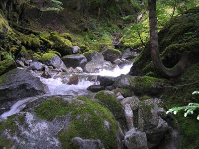
The creek settles down pretty quick from the base . . . because the slopes are gentle here; slightly more so that the bright-green mossy slopes of the upper course of the creek above the power lines. Rolling, I would describe them and it was a easy hike along the banks. But first I had to cross the creek to get to that easy side.

Right at the first jog of the creek from the base there is a strange structure looking much like a lean-to. I'd seen it from above and wondered. Now up close I'm still perplexed. Looks more like a WWII pillbox . . . slots in the concrete where one could imagine machine gun muzzles inching out. It was old and dis-used. I took a pic and continued on my way. Another fifty feet and there is another structure . . . a open-topped box of heavy timbers about 3x3 square and for the life of me I can't imagine it's purpose. Now, after-the-fact, I wonder if they have some sort of historical connection . . . perhaps associated with the railway intake of locomotive water from the creek (the water tower pipes do head in this direction on the blueprints). I lingered, shifted where the late afternoon sun was moving . . . and eventually found an old path following this side of the bank. An easy walk and I soon found myself on the Surprise Creek Trailhead access road. Naw . . . much too early. I turned back, headed slightly uphill to the east and found a sunny spot to lay out my towel and get some rays.
This is the spot the locals talk about when they refer to Scenic Falls . . . not the upper area of my previous post. Both are beautiful but this area doesn't have the magic I felt up above. This place is tranquil and serene . . . but not magical.
It is open hemlock stands. Very gentle slopes and open overburden between the widely spaced trees. I leave my pack and everything else except shoes, hat and staff to go exploring. Usually I do not leave my backpack and the safety and comfort it represents. But this area to the northeast of the falls is spacious and the sound of the falls unmistakable. There was no way I would get lost or be unable to find my backpack. I any case . . . there is something about hiking as totally nude as possible. It is invigorating and it is affimatating of the way I want to be.
I headed east, of course, because I'm still looking for that elusive trail to the Scenic Springs property. I should have started high. I always tell myself that and then never pay attention. So I traversed a half mile of open timber several times before I picked up an old, well-worn trail following another small creek up toward the easement area . . . and eventually I stumbled onto the 850 FS road at a spot just above the first bend from the gate . . . to the unknowing backsides of two soakers going down from a visit to the springs. Completely surprised me, but they didn't see me . . . fortunately. All they need is to see a naked man bursting from the forest with nothing but shoes on. What would they think? LOL I ducked back into the tree line, mentally cataloging the routes. Wintertime it would be an easy hike . . . snowshoes probably, but better than trying to park before the gate. There are some ankle-biters . . . gullys . . . to cross, but the slope is gentle and open and you only add a half-mile to the hike. Doable.
I headed back before I surprised anymore people headed up to the springs. I took my time and just ambled because this was great . . . an easy walk in the open forest. Eventually, I had to head back . . . and I made it to my pack without problem. And then back to the creek and the access road. I even dared walking the very popular Surprise Creek road nude. Chancy but I just didn't feel like putting clothes on after such a great afternoon.
For those that are interested in checking the lower falls out . . . take the exit to the snow park area near the railway tracks and drive just a short way down the Surprise Creek trailhead road. Park where the side BPA road goes off to the left and hike back up the road to where the signs warns that you need a pass to park at the trailhead (you do and you've got one, right?). Turn into the brush to the right and within twenty feet you'll see the banks of the creek. Just follow it in a couple of hundred feet and you'll be as surprised as I was. And if you see me strolling about naked under the trees there . . . say 'hello' and share the space with me.
BTW, as I sit here NIFOC, I feel the tingle of sunburn and realise just how strong the sun can be even under the protective filtering of forest canopy. No, I was too lazy to put on suntan lotion. Next time I will.
 This blog contains images of simple nudity.
No comments:
Post a Comment