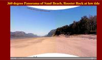
The beach at Rooster Rock was at it's widest expanse that I have seen it for years . . . as one person said, you could land an aircraft on it. Walking the beach on Saturday I took a moment to make a panoramic shot of the beach. The image you see posted does it little justice but if you drop me a line I'm more than willing to send you a copy of the full image.
 Since the blogging software will not allow java or javascript to run within the posts, I have loaded a full-size panoramic viewer with the above image of the beach here. It will launch in a new page (or tab) and since the image is 746KBs in size, please give it a chance to load and start scrolling. You may use the navigation button at the bottom of the screen to enlarge, reduce or manually scroll the panorama yourself.
If you are interested in the full-image, you can download it here. Enjoy
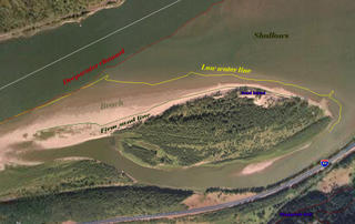
 As promised, here is an aerial image of Sand Island with the low water line marked on it (yellow), the limit of the hard packed or firm sand on the beach where it meets the softter sand (green), and the red line of the deeper channel of the Columbia River taken from the 2004 sat imagery. As you can see, there was a lot of beach exposed.
 Since the blogging software will not allow java or javascript to run within the posts, I have loaded a full-size panoramic viewer with the above image of the beach here. It will launch in a new page (or tab) and since the image is 746KBs in size, please give it a chance to load and start scrolling. You may use the navigation button at the bottom of the screen to enlarge, reduce or manually scroll the panorama yourself.
If you are interested in the full-image, you can download it here. Enjoy
 As promised, here is an aerial image of Sand Island with the low water line marked on it (yellow), the limit of the hard packed or firm sand on the beach where it meets the softter sand (green), and the red line of the deeper channel of the Columbia River taken from the 2004 sat imagery. As you can see, there was a lot of beach exposed.
 This blog contains images of simple nudity.
No comments:
Post a Comment