Monday, December 31, 2012

Another Below Freezing Nude Hike


It has been calculated that a naked man exposed to still air at or about 0 degrees C can maintain a heat balance if he shivers as hard as he can. However, he can’t shiver forever.  Cold Weather Survival, Ch 15, Pg 7

It always amazes me that my nude body can take the cold so easily yet, bundled up in full winter clothing, those same cold temperatures manage to send shivers of cold up and down my body.  Clothing, it seems, sends mixed and confusing messages to the regulatory system that controls how hot or cold I feel.  No matter the bulk of winter clothing I may be wearing, a cold breeze to the face will send my metabolism into high gear and suddenly I'm too hot.  Nude (or appreciably so) evens out the responses and I do find that I can withstand (and even enjoy) being nude in temperatures many of us would define as just being too damn cold.

The operant word in the above quote is 'shivers'.  As long as my body has not entered that first warning sign of impending hypothermia . . . the shivering . . . hiking nude in extremely cold weather is actually invigorating and not in the least bit uncomfortable.  The trick is getting out of the clothes in the first place!


Normally, a sunny winter day can actually do a lot to warm the exposed flesh of a nude person.  However, today the skies were deeply overcast and near twilight by the time I finished.

The afternoon started with temperatures right around 35F and soon dropped to 27F by the time I got back to my car and put some clothes on.

The way the frozen snow crunches underfoot, I'd be heard . . .
or I'd hear anybody else out there long before we met.

The hike wasn't a super-long one.  Only about an hour.  But it sure feels nice to absorb in the cold air and repel it with increased body heat.


Saturday, December 29, 2012

Article: Strange and Secret Places on the Oregon Coast

Note:  Clothing-optional opportunities on the Oregon coast (especially Hobbit Trail-read further below)?  Rick

Originally published in the Oregon Coast Archives, Apr 7th, 2011

Published March 07
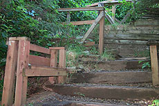
Stairway of 1000 steps at Short Beach
(Oregon Coast) - Oregon's coast is a different animal than the rest of this placid and pristine state. The area is rugged and battered by wind and rain, but it cloisters a load of pleasures and aspects not always obvious. Especially in the springtime, it's a mishmash of weather conditions, amenities you can't find at any other time, places to see with their own identity in this season, and wild, natural wonders to encounter.
In fact, it's recently become nicknamed the "Secret Season," or "Secret Spring."
However, at any time of year, there are places tucked away that will knock your socks off. Off the beaten path of 101, or perhaps even hidden in plain sight, these unusual beach spots are waiting to jolt the explorer with a bundle of features and facets that can create a kind of beach addiction. Once you find one of these strange and secret places, you’ll want to search for more.

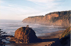
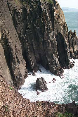
Short Beach and its blob
Short Beach, Near Oceanside
One of the state's most enthralling hidden spots lies right next to Oceanside, just west of Tillamook. Look for Radar Rd. along the back road between Oceanside and Cape Meares, and you'll find the refurbished entrance to this stunning beach. Until recent years, the way down here was precarious and slippery, causing many injuries. But locals got together and created a "stairway of 1000 steps," which is heavy breathing-inducing in no time, especially on the climb up, but a heck of a lot nicer than cracking your skull (which a few tourists literally did before this was built).
First, you'll find the bulbous blob at the tide line, resembling the sea stack at Neskowin to the south. Wander here a bit longer, and you may see the waterfall coming from the side of the cliff, which hosts the lighthouse.
Legends abound here. It's said that at extreme low tides, there is yet another tunnel visible (like the one through the cliff in Oceanside). One version of the legend says there may be two tunnels here.


Secret Lincoln City Access
In a town where the beaches are all easily accessed and usually quite populated, there are virtually no hidden spots. But there is one deliciously, extremely clandestine beach access at the northern end of town - even if it doesn't necessarily guarantee you'll find yourself alone on this stretch of sand.
At the very northern end of town, between the casino and Road's End State Park, look for the sign pointing to NW 50th amidst the placid neighborhoods. Follow that to its end, where it meets NW Jetty, and you'll find an abandoned gravel "driveway" which winds its way down to the beach. Along the way, there's another tunnel-like path that looks a little like the famed Hobbitt Trail (see this article), although that doesn't seem to lead anywhere.
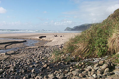
Down on the beach, it's the only access for about half a mile in either direction. There are some interesting rock features here created by a crumbling cliff, and the sand is pristine and more than a little pleasant.

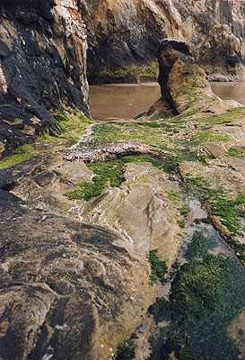
Near Short Sand Beach (Manzanita)
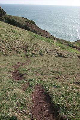
Just a few files north of Manzanita, you'll find Oswald West State Park. But somewhere between that town and the state park, it's impossible to miss the striking vistas of Short Sand Beach (not to be confused with Short Beach, above) and the cliffs that form half of this crescent-shaped cove.
Pull over on one of the gravel parking spots off the side of the road, and there's the one-mile-plus hiking trail heading down to Short Sand. Walk down this trail a bit, veer to the left - instead of going down to Short Sand - and you'll encounter a totally different set of inclines and cliffs. Giant basalt structures form the various headlands here, with craggy shapes jutting up from the ocean and bundling together.
In one area, the sea boils and tumbles against a hidden cove, with black, jagged spires forming something akin to a creepy, post-apocalyptic cathedral (sort of reminiscent of the "Planet of the Apes" films). Another spot visible from these dangerous cliffs showcases more of the jagged shapes, this time with enormous holes and arches in them. Through these, you can see other headlands to the north.
Be extremely careful here, however. The drop-offs here are sudden and deadly. In fact, it was near here where a famed Hollywood writer and producer – the creator of “COPS” - died a few years ago, after falling off a cliff.

Hug Point
A few miles south of Cannon Beach you'll find Hug Point. A waterfall, several sea caves and a raised, grotto-like tide pool within another cave are all just a precursor to one of the coast's most fascinating spots. Not to mention that always-engaging remnant of a road going around the rocky point.
As you first enter, you'll spot the waterfall immediately to the south of you and a large sea cave. Inside, it's mostly debris and cobblestones, but there are strangely shaped cracks and shapes meandering into its far end. You can wander a little ways inside, and if you look closely you may spot one of the creepy, alien-looking insects that inhabit the large cracks.
On the southern end of this beach there's a point that's normally not crossable unless the tide is sufficiently low enough. In such a case, you'll find another cove and another sea cave. There are more rock slabs to play around on, many of which are surrounded by rich tide pools.

Hobbit Trail
It's so named because the eerie tunnel-like earthen walls that surround you at certain points upon your descent. But it's a place sometimes favored by creative-types from the Eugene area who often construct wildly imaginative structures from the natural objects lying around, like amazing gardens of rocks, things you might find in Japanese gardens, strange rune-like figures from stones or whimsical carvings in the sandstone.
Or maybe is it occupied by gnomes who scurry away from their constructions upon the approach of any human being?
It’s also the coast’s closest answer to a nude beach, where the privacy often afforded here allows some of the more underground culture folk from the valley (OK, we mean the hippies) to trot around au naturelle.
You can find this hard-to-spot trailhead about two miles south of Washburne State Park. There's a breathtaking trail from here that meanders a little over a mile through forestland and the occasional stunning viewpoint, eventually twisting and switching back periodically to wind up in back of the Heceta Head Lighthouse.

Monday, December 24, 2012

Two Nude Snow Hikes in a Row

Okay, so I may be a little foolhardy but I've been so long without getting nude in the outdoors that I just had to take the opportunity for a follow-on hike before the really cold temperatures put a damper in my activities.


Surprisingly, the human body does a really good job of adapting to the cold.  It feels great to wander about in as natural a state as possible.


Saturday, December 22, 2012

A much needed nude snow hike


Find an isolated logging road and just go for it!
After five weeks going back and forth between Seattle and Wyoming for my employer (and finding limited opportunities to get nude on the High Plains), any excuse and free time meant I went off searching for time for myself to enjoy a nude hike for an hour or so.


Vantage Nude Beaches

One of many small beaches (marked by clumps of trees) overlooking
the scenic views of the Columbia River Gorge

Traditional clothing optional desert-terrain lakeside nude beach areas on the shores of the Columbia River in Central Washington State. Located just off the I-90 freeway NW of Vantage, Washington near the famous 'The Gorge Amphitheater.' The nude beach areas are located several hundred yards down the lake beyond the parking lot. Though technically not 'legal' it is a long traditional and accepted nude use area. Follow the popular trail along the lake starting next to the boat launch area. There is a mix of clothed and nude users. Weekends see numerous boaters and hikers. Weekdays are quieter. There are sand dunes, hiking and swimming options. Watch for Rattlesnakes. The DNR property along the lake is leased to a private group who allow nude use as long as everyone behaves and cleans up after themselves. Sheriff Deputies and PUD employees tolerate nude use and don't bother anyone...unless they are given a reason to interfere...so don't give 'em any reasons.


Directions:
  • Take I-90 over the Columbia River and up the bluffs to Exit 143, Silica Road and left over freeway.
  • Take the next left onto Vantage Road/Frontage Road.  Follow this nicely-paved road four miles down the bluffs to the parking area/boat launch at the bottom.
  • A Fish and Wildlife Permit or a Discover Pass is required to park and use the area.  A list of retailers nearby where you can buy a pass is here.
  • Park, go thru gate and follow a dry gulch on down.  Nudity is generally tolerated once out of sight of the parking area.  The beaches are a series of small beaches (each marked by a clump of trees).  The first beach is easily noted by a barren telephone pole with a birds nest atop.
  • For easier walking, bear left thru the gate to a gravel road and follow that down until you see a beach to visit.


a


Friday, December 21, 2012

Juniper Dunes - An Update

From the entry in my Clothing-Optional map at:  http://www.communitywalk.com/clothing-optional-places#00036GC


Desert sand with rare Juniper trees and other low vegetation. 19,860 acres with 3,920 open, 8,620 limited to designated roads and trails (area of critical environmental concern), and 7,140 acres permanently closed. The topography is characterized by flat or rolling relief caused by wind deposited sands and silts. Vegetation in the area is comprised of a mosaic of habitat type ranging from those dominated by sagebrush and rabbit brush to open grassland with scattered Juniper trees. Land use includes hiking, camping, hunting, & horseback riding. Summer temperatures can reach well over 100 degrees F and can plummet to near zero degrees or below in winter.

Impressions: Inside the fenced region (around fifty to a hundred square miles), the chance of encountering another person is extremely remote. I have never had it happen. The sign-in sheet gives an indication of the presence of any others. Usually, you will find that you are the only person(s) there. The dune area outside the fence often contains a handful of dirt-bike riders, which can be heard at a distance. This means that carrying a cover-up is not necessary. On nice days one can simply tank up on food and water, then head in with nothing more than a pair of sunglasses for the day and maybe some sandals if your feet are soft. Some care is prudent when entering the fenced area, however. Remember, you are on your own! There is no water available and there are no developed trails. Campfires are not permitted; only portable campstoves. Think WILDERNESS. If you're the sort with no sense of direction, it would not be at all difficult to get lost. The terrain consists generally of rolling hills for as far as the eye can see, with no towering landmarks to act as reference. Attention to detail is important, though you technophiles could instead tote a GPS receiver or a trusty compass. The best time to visit is in the spring, ideally soon after a rainshower. You'll find many plant varieties in bloom, giving the terrain a splash of color. Moisture makes the ground more firm for easier travel, especially on the roads. Second best visiting time is in autumn. The temperatures are moderate and there are a few plant varieties that bloom then. As in the spring, the air is filled with distinct scents. Summer temperatures can easily climb well over one hundred degrees F. The humidity is quite low, so it's not that uncomfortable as long as you have plenty of water. As in most desert climates, the temperatures can get significantly cooler at night -- dropping from a hundred-plus down to mid-seventies. One summer nuisance to be aware of are the invader species of plantlife. The cheatgrass is growing in areas, particularly widespread around the perimeter. This grass dies in early summer, leaving pointed seeds that work their way into everything. If you wear socks or closed shoes, you won't penetrate very far before being turned back. It's best to wear open sandals or thongs -- spring is about the only time one can travel barefoot, while the grass is still green. Just watch for the occasional patch of prickly pear cactus. Fortunately, the tumbleweeds and tackweed haven't established themselves too well yet in this area.

No water and no facilities, so bring everything you need.

Call the BLM office in Spokane before going out to be sure you can get access: 509-536-1200


Since that posting, access to Juniper Dunes has been problematical at best.  The traditional route into the wilderness had been via Peterson Road, a private road about five miles along the Pasco-Kahlotus Highway from I-12.  The owners of that road had cut off access on and off for years, sometimes threatening, sometimes bulldozing a berm across the road to prevent access to the wilderness beyond their properties. That was the quickest and easiest access that got you to the southern edge of the Juniper Dunes Wilderness.

The large, yellow mailbox that is the landmark to Peterson Road
Serious, "Keep Out" signage just inside Peterson Road


A Better Route Into the Wilderness

On my recent, job-mandated road trip to Montana and Wyoming I found myself driving back along I-82 near Pasco and on a lark (and overnighting in Pasco) decided to see if I could find a new way into the Juniper Dunes Wilderness area that did not illegally cross any private property.  Spending a few hours going over Google Maps of the area I came up with a feasible alternative  that seemed to show a trailhead parking area real close to the northern boundary of the wilderness.  I set off the next morning to see if sat. images matched reality.

The route:
Drive 23.8 miles from I-12 east on the Pasco-Kahlotus Road to the Snake River Road.
Take a left.
After 3.5 miles on the Snake River Road, take a left onto
Blackman Ridge Road, a well maintained gravel road.
At 2.4 miles, take a left onto Joy Road and follow it all the way down to the end.

The Juniper Dunes Ranch is about half a mile down Joy Road.
The property owner has allowed access over a short section of
land at the end of  that road.
How could I not resist getting a picture of myself nude at the rules sign?
However, I respected the property owners wishes which were ...
... access only during March, April and May.  The wilderness area starts
just beyond the cultivated area with the first set of dunes.
Since this route only leads to the Wilderness Area and not to the OTV parts of Juniper Dunes, many of the problems that caused disputes and closure of the southern access route (trail bikes, OTVs, noise, speeding dust, etc.) are ameliorated.  You can only go into the Wilderness on foot from the northern boundary.  The one and only time I have been into the Juniper Dunes Wilderness I never saw another human being for the entire day.  I look forward to getting back down there this coming spring after March 1st.


Related Posts with Thumbnails