
Nude GeoCaching: Foss Moss
Foss Moss by bangedupshins (2/1.5)
N47° 39.572 W121° 17.970 (WGS84)
UTM 10T E 627680 N 5279860
Use waypoint: NWP002 User Data: Nudibility Potential Very Good
Size: Regular Hidden on 4/16/2006
In WA, USA
Difficulty: ![]()
![]() Terrain:
Terrain: ![]()
![]()
| This is a multi - cache consisting of hiking to two locations in the nude to obtain the directions to the actual cache, located within an ammo box. The clues will take you on a hike of approx. five miles (round trip) . . . plenty of time to enjoy being clotheless. How you prove you did the search au'natural is unimportant. The whole purpose for this geocache it to enjoy doing something au'natural in a relatively nude-safe location. There are no reporting or logging requirements other than to sign the log and let me know you've found the cache. This location is off the beaten path. The dirt road has been decommissioned and does not even show on the newer topo maps, so you should not have any problem hiking nude; I never have and I've free-hiked it dozens of times. It is one of the few locations you can walk away from the crutch of clothes and not have to worry about quickly covering up. That's how unvisited this location is . . . Access: Take SR2 past Skykomish and the Skykomish Ranger Station. Just past the Last Chance Espresso take the right onto Foss River Road and follow it in as it become a gravel forest service road. Continue past the Tonga Ridge turnoff, the Necklace Trailhead and the Foss River Campground turnoff. You will go over two short concrete bridge. Watch your GPS for indications of the unnamed narrow gravel road to the left. The starting point is a few hundred feet up that road. |
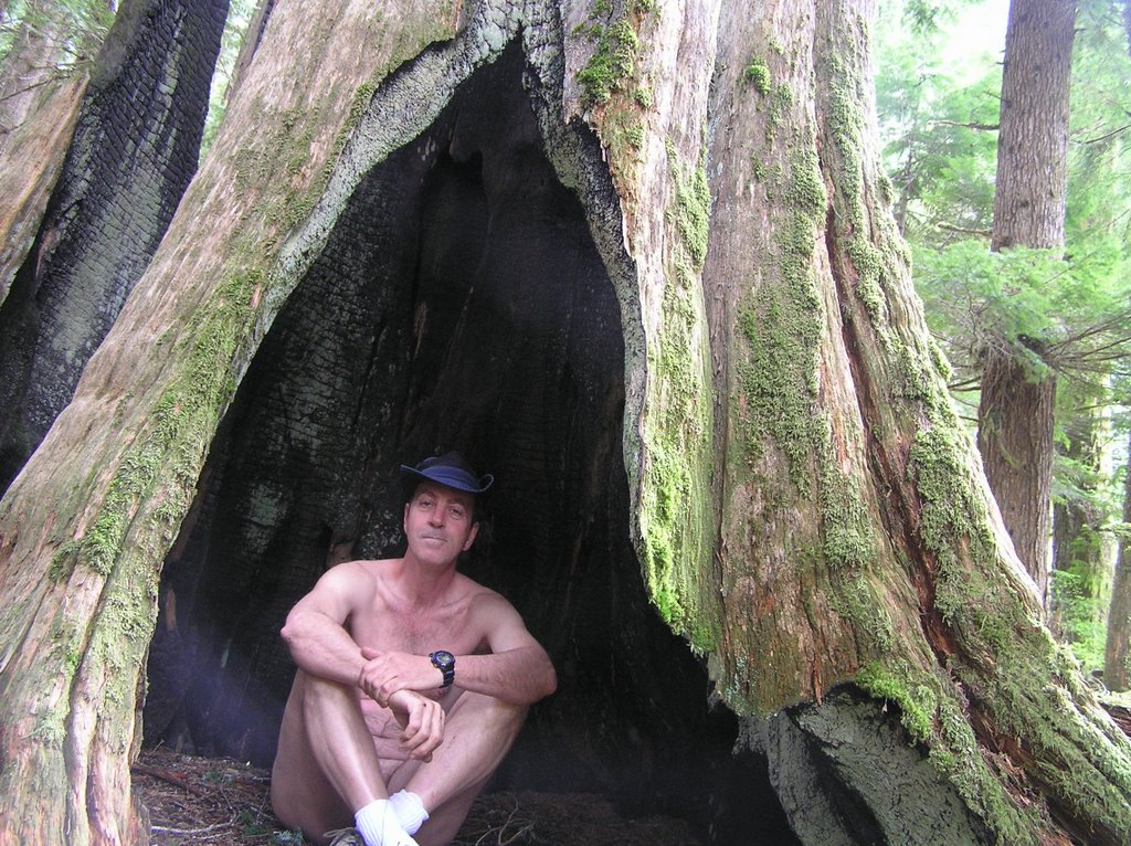
First Clue - The Posted Coordinates The dirt roadway has a short concrete spillway in case the creek overflows it's culvert. Just before this spillway is an area where you can park your vehicle. There is a campfire ring to which the coordinates point. Go off the road 50 feet or so on the downhill side in the general area of the creek. In your explorations of this area near the road and creek think of the effects of a lightening strike on a large tree and then look for the magical, human-sized opening. Once inside, check out the tunnel-like view of the sky from inside. You will see it.. Follow the simple instructions on your GPS unit that are printed on the card. Secure the clue for the next seeker.
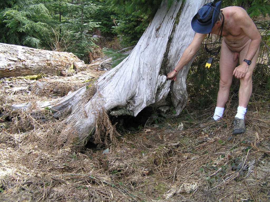
Second Clue Time for a hike up the decommissioned dirt road, setting waypoints as directed. After the second waypoint is entered, set the GPS to GOTO this waypoint and watch the distance indicator until you are approx the proscribed distance away. You should be in a turnaround clearing. At the end of the clearing on the uphill side you will see a jumble of logs, and one very obvious upright propped log (it is pretty much weathered). Again, note the instructions and rehide the clue. Now is the time to enjoy the view, catch some sun and perhaps have lunch.
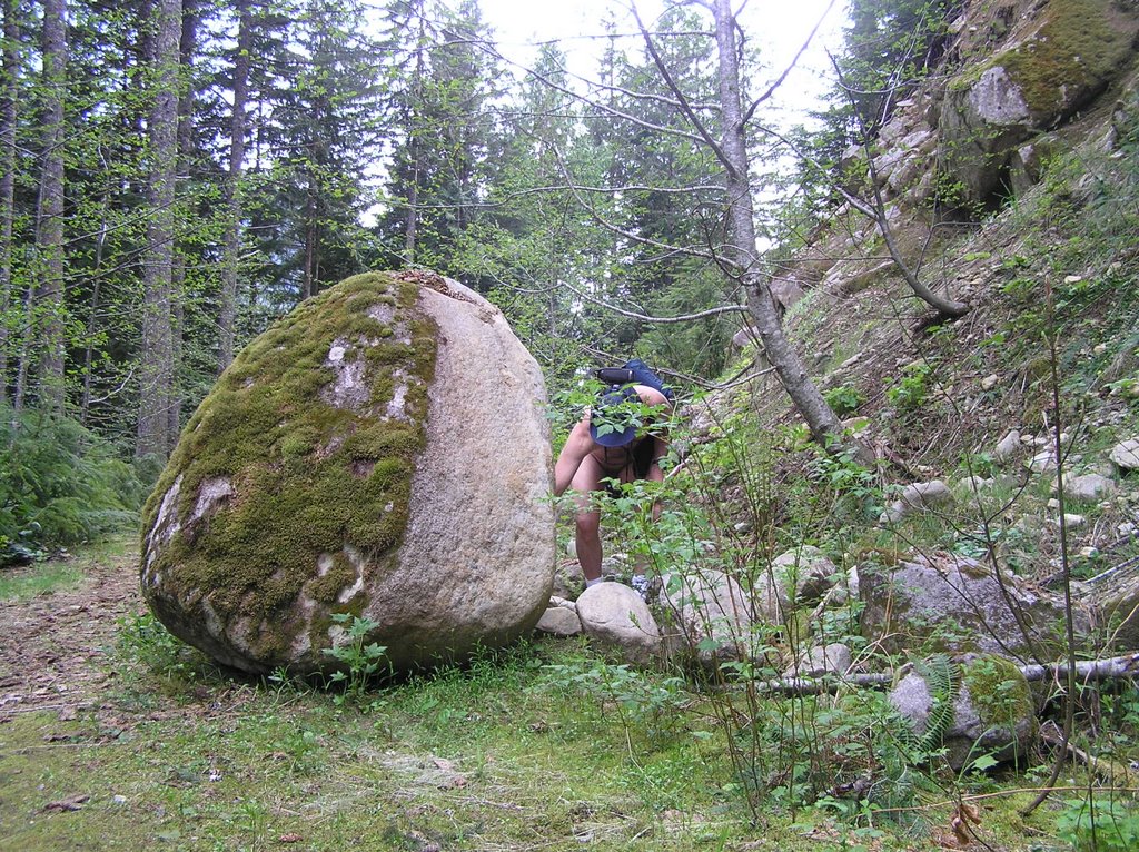
The Cache Did you see it and wonder on your way up? The cache is approx 550 feet due south along the obvious wide path but you don't need a GPS unit to find it now. The cache is concealed behind an obstruction right next to the overgrown trail within fifty feet of the far end of the bridge.
Note: Although the instructions indicate you will enter the brush at points, this is very open terrain and you should have no need for protective clothing other than a good pair of hiking shoes and some light-weight utility gloves. If you have parked just short of the spillway you are already out of sight of the main road and near your first clue. You can strip right at the car and leave your clothes there for this search. All you need is your GPS unit, a compass and a good eye for distance; plus a water bottle and perhaps a lunch to enjoy in one of the clear-cut, sunny areas you will cross. You may need a small flashlight to read the first clue and a small memo pad and pen is handy to write down directions.Safety: This cache is located in National Forest and in a relatively unvisited area. Take normal precautions and be aware of your surroundings. Black bears are known to forage in the Foss River valley down below. They are shy creatures and avoid humans but be aware of the time of year and the potential for bears foraging berries along the side of the abandoned road.
A bigger problem are the deer flies that hatch in early August in waterbound areas at the higher elevations . . . particularly Evans Lake. Be prepared to deal with DEET. Also consider sun exposure at the higher points.You cannot get lost on this search; merely follow the road track back to your car. Do not attempt to drive your car past the short spillway. The road quickly narrows and presents few turnarounds unless you have 4WD and adequate clearance.
Additional Hints HintsCurrent at 4/16/2006
Decoded Hints
| They say a rolling stone gathers no moss. But this large boulder has been sitting beside the trail long enough to become Foss Moss! Spoiler #1: The location of clue #1 can be seen in pic # 1 Spolier #2: The hiding location of the 2nd clue is in pic # 2 Spoiler #3: The cache location is obvious in pic # 3 . . . if you can figure out where the picture was taken. |


|