
Silver Creek-Mineral City: Grin and Bare It


I gave myself a present today . . . I took some time off for myself, by myself. I did a hike I'd always wanted to do but lacked the time. With another beautiful, sunny day and things stable with Ted it was time to stretch the legs.
The trail up Silver Creek to Mineral City is not well-marked on most maps, and is certainly not signed nor listed with the Forest Service. You get to the starting point a little more than nine miles (9.3) down the Index-Galena Road, zeroing your odometer at the Highway 2 turnoff for Index. Immediately after crossing the wood-deck bridge over Howard Creek you take a left to cross the bridge over the North Fork of the Skykomish River. The road immediately become dirt and forks straight and right a couple of hundred feet on the other side. Straight heads up Salmon Creek and right slips around the bulge of the mountainside toward Silver Creek. I took the Silver Creek right. It is drivable (in my Civic) about a mile up. I could have parked at the road fork with easy access and so on but I didn't trust leaving my car there. From my previous forays into this area I knew there were a number of pullouts to safely park a vehicle out of prying eyes and idle hands. I also thought the road obscure enough that the car would be safe for an extended period.
The one time I hiked a portion of this road, it deterioated quickly into a jeep trail. I'd only scouted about a mile in and never saw anybody. Some 4WD tracks to a clearing that is obviously used for the gun aficionados but then the road gets even rougher. Beyond the few rustic cabins down below on the west side of the river that need access, this road seems to have been decommissioned and left to revert beyond the one mile point. The 1972 topos show the road continuing around the bulge of the mountainside and up the south side of Silver Creek in a northerly direction. With the road falling apart so much, I wondered how accurate those maps were.
I parked my car as far in as I dared. All the property along the river is private and so signed. There are a few points where signage is absent and I trekked down for a great view of the river. Then it was back to the task at hand . . . Mineral City.
The Galena claim (which lies dormant the best I can figure out) is a followup to the copper, silver and gold finds in the regions to the north . . . the most well-known, the Monte Cristo claim. Mineral City is less well-known and lays about four miles up the Silver Creek valley near the base of the 8,000 ft Silvertip Peak. On the other side of Silvertip lays the valley of Monte Cristo. A trail runs through Poodle Dog Pass between the two sites (an adventure for a later trip). Other than way the topos told me, I knew nothing about the terrain or conditions . . . or even the present existence of Mineral City. I just knew that I needed a good nude hike . . . really the only excuse I ever need.
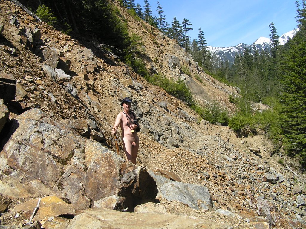
A four mile hike in and four miles back is right at the verge of me bringing a backpack in case it takes longer. I decided to travel really light with just my thermos (did I mention I like my coffee), and a fanny bag. I undressed right at the car, confident that I had the road to myself. Normally I would carry a pair of shorts in case I needed to cover up but that seemed superfluous. I was not going to meet anyone going in or I would have seen another vehicle parked. By the time I would be coming out it'd be too late for newcomers to be inbound. I was wrong on the last count. I left the shorts and teeshirt on the front seat of my car, locked it, and started the easy hike up the still drivable road.
The full sun to my back felt good. I felt a little nervous being in full view on a straight road . . . thinking, that I really don't know where this road leads and who might have a reason to be driving up it (or back down). Then there were the deep-tread tire marks from a jeep or similar vehicle that were made within the last day or so. Instead of worrying about such intangibles I immersed myself in the surroundings and the ever-present noise of the rapids in the river way off to the right down the steep slopes. Soon the road became too torn up for anything but a jeep to negotiate . . . which the tracks did. But they were from a day or so before. I relaxed and let myself enjoy the glorious feeling of walking nude in the sun and trees and breezes so gentle on the skin.
 The grade is gentle (as the entire hike was to be with a few minor hurtles). About a mile and a half in the road Y's with one fork heading uphill to the left and another straight. This didn't show on the map. A left would be required to turn into the valley of Silver Creek but instinct told me not the trust the left fork. I tried straight ahead. Within a hundred feet the road ended and became a footpath onto a huge pile of talus and skree. The path across was obvious and seemingly well-maintained.
Strangely, the open road behind me (as torn-up as it was) had made me edgy. The moment it became a trail I was in my environment and could really relax. The sun was bright and full on the talus and Silver Creek was roaring far below over thunderous falls. I took my first break here, kinda reluctant to re-enter the stunted tree line and give up the full sun.
 The path across the skree is narrow . . . no more than 18 inches. The skree is also very loose and one misstep or loss of balance meant a several hundred foot fall down an extremely steep slope of razor-sharp rock to the raging creek below. I made sure of my footing. Still, I was surprised that the obvious footpath was in such good condition after the winter. For an obscure trail, someone was maintaining it.
The trail picks up an easy level path on the other side. This was once a mining or logging road as was obvious from the reclaimed width. The evidence of maintenance is all around with machete-work on fresh-cut saplings to keep the trail open. On the downside of the slope there are numerous terrain-benches perfectly suited for camping, which the campfire rings attested to . . . though not in use today. Have I missed a perfect gem of a trail?
 I come across my first mine shaft opening in a solid pluton of iron-oxide stained rock. It is right there beside the trail. I explore the entrance briefly but there is no way you would catch me going inside. Still, the mine shaft was unexpected and not on the map nor the mines database I'd consulted earlier. There would be a few more. That it was once a narrow road is obvious at this point. What is more interesting is the roar of rapids and falls from the creek (river?) below, whicj have been accompanying me up.
 I reach Quartz Creek (which had confused me when I researched the route because there is another Quartz Creek that is a favorite hike of mine; they are unrelated). This is the one spot on the map were the trail stops and then picks up a short distance later. Now I saw the reason. There was a huge chasm seventy feet across and a like distance down where the bench had been washed away. If there was ever a bridge across this it had long ago disappeared. How do I get across? The sides were sheer and unstable. A few moments later I spotted the ladder down to the bottom. It took some reluctance and careful testing before I trusted my naked self to putting weight on the rungs. The ladder was almost vertical and at an unnatural sideways cant. Quartz Creek rushed by and had to be forded at the bottom . . . and then it was pull myself up the steep dirt bank on the other side by a brand new climbing rope that someone had thoughtfully left there. Brand new . . . no dirt or weathering. But why? Who was maintaining this trail? This was not Forest Service work.
 The next few side creeks and gulches have vehicle-width wood-plank bridges across them. All of them are in disrepair with rotten planks and in one case an entire longitudinal support dropped one hundred feet below into a raging gorge.
 I step carefully, prodding the wood deck ahead with my staff, listening for the dull thud of wood wanting to give out. I don't think these bridges will last out more than another season or two. For now, they hold my weight, which is inconsequential considering the vehicles these bridges must have been constructed for. I feel confident enough to enjoy the waterfalls coming down off the Crested Buttes far above . . . or the great views of Silver Creek raging far below.
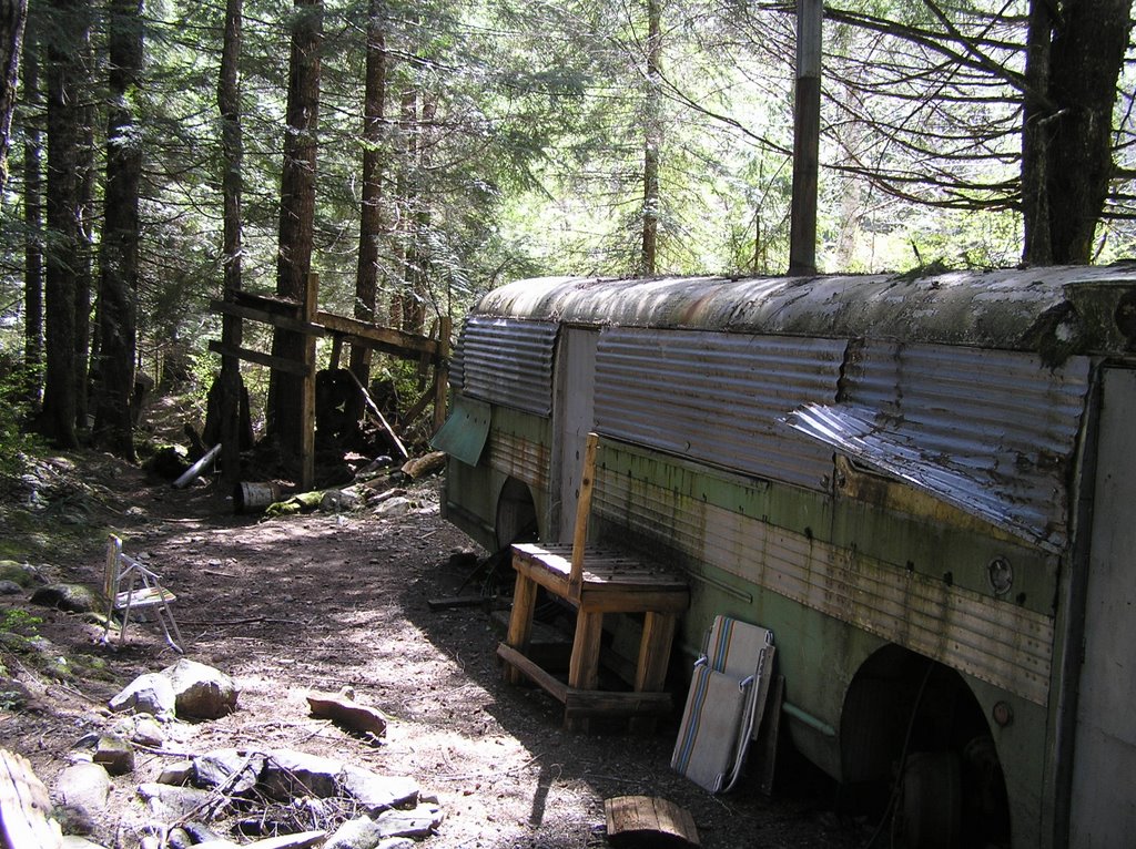 Back on the level trail after another section of talus and skree I spot something out of character in the treeline ahead. Shape and color, it looks artificial, and as I get closer I realize it is an old bus. I slow. Is someone living out here on Forest Service land? Squatters? Drug lab. As I get closer it looks disused so I approach it. Seems sealed up. No tires; windows sealed over with metal . . . almost looks fortified. One section of metal has been pried up . . . someone taking a look-see. I take a look as well. Hasn't been taken care of . . . spider webs and such inside. There are a couple of lawn chair stacked up outside that do seem relatively new . . . but no one is around. I continue on my way.
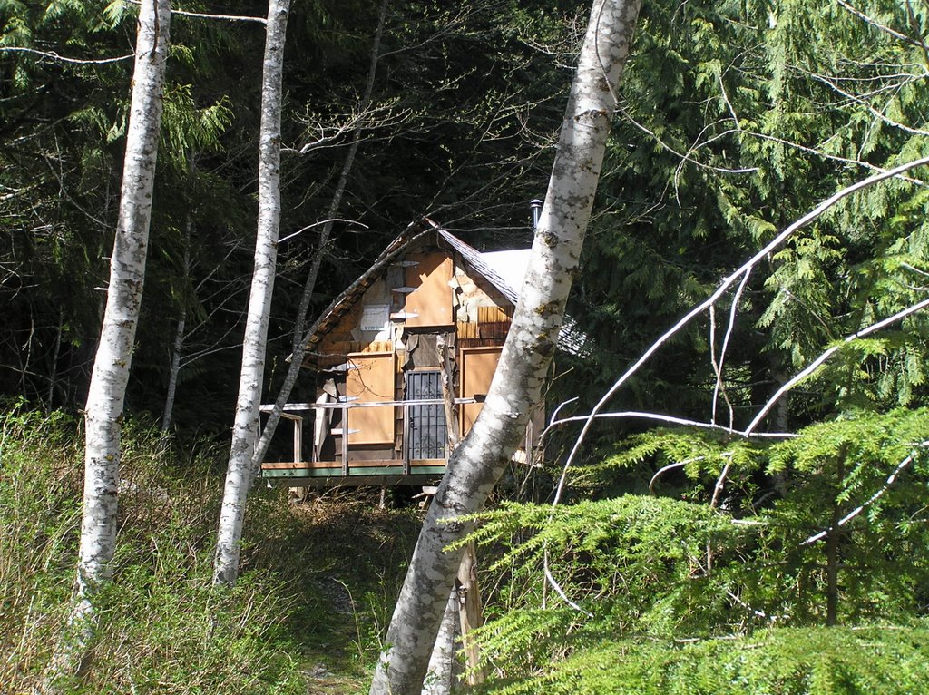 The cabin takes me by surprise. It is right off the trail in a flat area with No Trespassing side posted. Like the bus, the cabin is all boarded up but looks in good shape. The metal chimney sticking out of the roof is new. Still, no one is around and I'm pretty sure that I am on National Forest property. The 'No trespass' is not on the trail so I continue past.
 The trail gets wet now. I pass another old mine opening in the solid rock next to the trail. Trail maintenance seems to have stopped around here as the new growth is encroaching. Fallen trees make for climbing over or detouring as I start to enter the residual snow at this elevation . . . just patches of a couple of inches . . . more in the flat areas to the right. Near the head of the valley, my GPS said 7/10s of a mile. I look at my watch. I can't afford the extra half hour . . . not without being able to see an obvious target through the young trees obscuring the head of the valley.
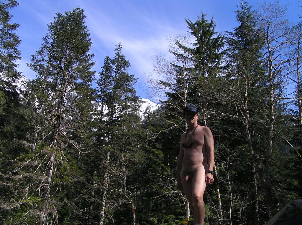 I decide against trying because I have to be back in Carnation by seven. Reluctantly I take a quick break and then head back down.
I met my first hiker soon after passing the bus . . . inbound for camping. Took me completely by surprise, but I didn't have any shorts to cover up if I wanted to. Grin and bare it; he was totally non-plussed and we exchanged ideas on how much further he had to go and the bus and cabin on his way (it was his first hike in as well). Not a bad encounter at all. I hiked on. I realized as I hiked that the encounter had been so easy because without shorts there was nothing to panic over . . . nothing to hurried grab and try to slip on. I may not go sans backup shorts on all nude hikes but today, being without that crutch made everything else all the much sweeter
It wasn't until I was well on the gravel road within a mile of my car that I had my second encounter . . . a couple with their dog. Again, what can I do but be natural . . . I smiled, petted the dog and we chatted about their destination . . . which wasn't far. It was as if I wasn't naked at all. Actually made me feel real good inside. The rest of the hike back to my car was uneventful, though I did find myself slowing down as I got closer . . . to prolong the experience. What a wonderful day!
Tags:


|