
Rooster Rock well under water
 MIKE SIEGEL / THE SEATTLE TIMES, © 2006 The Seattle Times Company
Image from todays Seattle Times on Columbia River Pollution Woes. Taken from Crown Point above the river looking to the Gorge, what is apparent is the amount of water inudation of the clothing-optional area of Rooster Rock State Park below. Only the highest portions of Sand Island are visible above water.
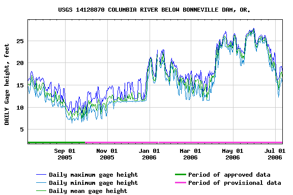
I was recently asked when the water levels will be going down and I'd like to offer my response:
I was recently asked when the water levels will be going down and I'd like to offer my response:
The water gets lower that by the beginning of August there should be an appreciable beach at the end of Buffalo Trail and you should be able to wade out to Sand Island if you are careful . . . the the water will still be bellybutton to chest high and deeper many places. The river is
higher than normal this year . . . at 17 - 19 ft (measured below Bonneville).
Water levels will steadily drop as we go into August with the mean around 15 ft and dropping to around 10 ft by the beginning of September. The water levels stay steady throughout the months of September and October before beginning the rise slowly again during November.
In general (a couple of people are working on a model for the group); when the water level (as measured at the Bonneville gage site) is:
>15 ft (beginning of August) - most of the clothing optional area and the un-vegetated areas of Sand Island are covered by water,
12-15 ft (into the middle of August)and it is possible to wade/swim out to Sand Island though little beach will be evident,
10-12 ft (last week of August) and much of the beach is becoming exposed and the trails/vegetation are drying-up. As the water level approaches 10 ft you will be able to walk to Sand Island in no more than ankle-deep water.
USGS Water Levels at Bonneville


|