 |
| Near the summit of Mount Persis |
A belated posting of a nude hike I did August 10th of this year . . . the past week has been busy what with my employer going through the final stages of bankruptcy and the new company experiencing growing pains . . . and a few scheduled doctor visits. Just never got around to writing the hike up ...
Mt Persis is the companion (some say the Little Sister) to the imposing upthrust of Mt Index which commands attention from everyone who travels down the US 2 corridor from the west toward the Cascade Crest. These two mountains foretell the change from foothills to mountains once outside of the town of Goldbar and nearing the town of Index.
Side Note: The present Mt Index is actually the second Mt Index . . . the present-day Baring Mountain a little bit further east originally being named Mt Index before being renamed.
Mt Persis actually shares a high elevation saddle with Mt Index, tying these mountains together and providing the easier route to scale Mt Index from Mt Persis. For now, Mt Index is much beyond my abilities and skills but Persis is fully capable of being conquered by a hiker without technical requirements. I attempted the hike once before, only to be stopped by a snowfield over a talus slope that I felt was simply too unstable. For a few years, closure of FS 62 to the public forestalled any thoughts of trying again . . . until last week when I went off exploring for a possible hike (now that FS 62 is again accessible.)
 |
| The southwest Ridge Route up Mt Persis. |
Reaching the trailhead is straight-forward though sometimes a little rough on the undercarriage of your vehicle. Follow FS 62 in as it wends and climbs into the Proctor Creek Valley (watch out for logging trucks on this very active road). At about the 3 1/2 mile point the road forks. straight and to the right continues on to Lake Cavanaugh. Left continues up onto the southwest flank of Persis. As the road gets rougher and does a couple more switchbacks, it forks on more time. Stay to the left and uphill and drive as far as you dare. I made it about 3/4s of a mile from the trailhead and parked in a small pullout. I would have to hike the rest of the road on my own two feet.
This far in I've rarely seen cars and I felt that as rough as that road was getting that it was unlikely anyone else had managed to get further up to park at the actual trailhead. The day was hot, humid and stagnant. Stripping out of my clothes from the beginning was a no-brainer. This time I remembered to bring the sunscreen spray and coated my body from head to toes. I would be heading high in elevation where the sun would be much more intense. Sunburn I did not want to deal with later. A couple of bottles of water downed and a power bar snack for ready energy, and it was off on the final stretch of road to the trailhead.
 |
| I had to laugh later . . . the sunscreen gave me that oiled-body glistening look ... |
Hiking up the remaining sections of the road to the trailhead in the heat of the day . . . still and very humid air . . . a solitary Deer Fly decided to accompany me with kamikaze darts around my head. August is the time for the more aggressive biting insects such as Horse and Deer Flies and the one thing I had forgotten to bring along was an insect repellent (much as I hate using that stuff on my bare skin). Fortunately the Deer Fly only seemed interested in pestering me out of its' territory. As soon as I reached more open areas with a little bit of breeze . . . Ms Deer Fly disappeared . . . much to my relief.
 |
| The Trail Head . . . not necessarily promising |
The trail head is not marked or blazed . . . simply a dirt ramp leading steeply up into the brush above. There is a car parked opposite the entrance and I feel a moment of disappointment. That meant someone else was on the trail ahead of me and had been for some time judging by the cool hood and brakes. I had brought nothing with which to cover myself up if necessary and I was certainly in no mood to hike all the way back down to my car to grab my hiking kilt. Anyone heading on up to Mt Persis had to be a fanatic . . . and probably not too concerned with naked hikers such as myself. I'd go on as I was because I just had to experience the wide open ridgelines and intense sunlight of this mountain.
 |
| Steep and closed in, the beginning is a scramble up |
The first couple of hundred feet on the trail turn back many. The trail is extremely steep with tricky footing . . . the foliage is close-in, in many places less that half a foot open space to squeeze through. Nude, it is a challenge but in the same respect, enjoyable to feel the supple brush slide around and off your body as you squeeze yourself through. Soon enough you are in the open as you gain the lower stretches of the ridgeline.
 |
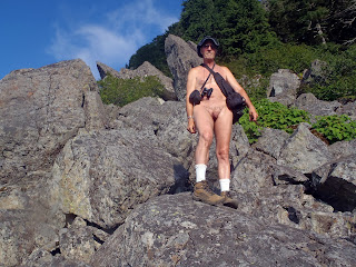
| On the open ridge line of Mt Persis |
The trail on the open ridge is obvious from its' lack of real definition. You instinctively know which way to follow up because the crest of the ridge is so narrow. There really is only one way and it is continuously steep. For me, the breaks are many and I find that I'm working new muscles such as the pains in the quads are showing.
The sun is intense up here and I sweat heavily. Fortunately, I've brought a couple of bottles of water and electrolyte replacement to deal with dehydration.
 |
| Yeap . . . there is a lot more upward trekking to do. |
So far the route has been much as I remembered it from my last attempt several years ago. I've seen no evidence of the earlier visitors and this wide open ridge would give me plenty of warning of them coming back down. Up ahead, just beyond the stand of trees is a steep portage around and up the base of a large, solid outcropping of granite . . . the steepest part of the hike and bordering right on becoming technical.
 |
| The view from atop the granite mastiff. |
On my previous attempt I was defeated by a large snowfield covering a talus slope. At the time I felt that the snow covered voids that were simply too unstable. By August the snow had disappeared and the unstable rocks of the talus slope presented a new challenge.
 |
| On the talus slope seeking the unmarked way across. |
I'd learned my lesson from a previous talus crossing where I'd gotten my foot trapped between shifting boulders. I stayed high, tested each and every step first, and made sure not to place my feet where a boulder could suddenly move and trap me anew. It took some time to navigate my way across and find where the trail continued on the far side.
I made it to sturdier ground amid trees and took a breather. As I was sipping on the second bottle of water I heard voices descending the area above. They were on me just like that . . . a father and his two boys. They had made the summit and related their losing the trail several times just ahead. They asked about how far it was to the talus and I told them just a little way, pointing the open area just below us. As they took off the father offered that there was no one else up there . . . all in all a friendly encounter with no one in the least perturbed about my nudity.
 |
| So close . . . |
I finally reach the level area traversing to the true summit of Mt Persis only to lose the trail in a mass of new growth. I'm also cognizant of the time and don't have enough of it to scout a route. Reluctantly, I turn around to head back down. Little did I realize it . . . the hike down took more out of me that going up . . . constantly checking myself on the steep slopes.
 |
| Making it back to the car as I lose the light of day. |


|