Some sunshine, lots of threatening clouds, snow, rain, wind . . . but a day free to myself and a chance to get out hiking. What other excuse do I need?
The day started out with a meeting in Monroe with the other steward for Scenic Hot Springs. We were going over plans for a class on Map Reading and Compass Technique that we are planning to offer this coming summer. After the meeting . . . since I was already 30 miles closer to Scenic than when I started out, I decided to continue on into the mountains. In Monroe, the skies were somewhat overcast but comfortable with frequent outbreaks of sun. The forecast for the afternoon called for general clearing and more sun. So, a hike looked like a good idea . . . especially since all of the coming week was tied up in mundane, but important issues.
Scenic was decidedly too cold with threatening clouds when I arrived at the base of the mountain slope. I can take a lot of cold when I have sunlight bathing down on my bare skin but that was not to be today . . . at Scenic with record amounts of snow to navigate on the way up.
On my way back down I turned on a lark onto the access road leading to the Deception Creek trailhead. I really didn't expect to get too far in . . . expecting lots of snow to be remaining on the Forest Service road once it was under the shade of evergreen canopy. Much to my surprise, it was clear all the way to the trailhead. And, there were no other cars there. I had the place to myself.
 |
| Road clear but trailhead shrouded with remaining snow cover. |
Deception Creek wends a low, forested valley for miles . . . actually descending quite a bit before making its' PCT connection rise to 5,000ft at Deception Gap, midpoint through the Snoqualmie-Mt Baker National Forest between Highway 2 and Interstate 90. During summer it is a convenient shortcut to cut across the National Forest, though the full trail is not a simple day-hike. It is a pretty popular trail, especially on Saturdays like today. However, during winter and into late spring, snow . . . deep and unwieldy . . . is going to hamper even the most die-hards after more than a couple of miles. Snow is still covering half the trailhead parking area (at about 2,000ft). A peek beyond the trailhead sign reveals deep piles of snow protected by the shade of the canopy. Not my idea of getting a healthy dose of vitamin D.
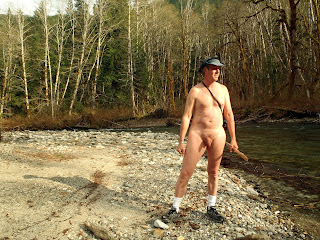
But standing nude in the empty parking area with the sun coming out from behind the ever present morning and early afternoon clouds, it felt good to soak it all in. Three pm . . . much too late for anyone to be arriving for an arduous hike into Deception Creek. On previous visits to this trail I've considered a spur road splitting just before the trailhead and heading up into the clearcut of the BPA corridor. The network of maintenance roads spiders quite high on the slopes for servicing the upper towers. That is doable and it is in the open . . . so I should be able to enjoy as much of the afternoon sunlight as is available. So, backpack on, off I head . . . up and to the east in the clearcut.
On topos, these maintenance roads are shown to eventually connect with the western-borne maintenance roads originating out of the Surprise Creek area. That has often intrigued me because I've hiked the entire length of those roads from the east and run into a deep, impassable ravine at an evident end to the road. I wondered if there was once a connection with evidence from the western side over the northern flank of this unnamed mountain.
The hike up was extremely enjoyable in the lower stretches. Some snow, easily walked upon in my boots . . . more surprisingly, the number of detours around slid areas I had to make. This maintenance road is in dire need to repair if they ever expect to service the BPA towers up there, but for me it means I can expect no surprises as right now this is walk-in only. Tire tracks reveal where some off-roaders have tried and given up. Beyond the first detour through fallen trees and deadfall, I have the entire slope to myself. It's a great feeling to switch your antenna from listening for others to attuning to the stimulus of what nature offers. everything is beautiful up here . . . even the rubble of seriously eroded roads.
 |
| As far as I can go from this direction. There is no more road. |
Halfway up the rain starts. And then as I crest the mountain flank, the winds. It was 45F when I began (I always do a mental comparison to a refrigerator at 40F when thinking of nude hiking temperatures). But I had some sunlight and the exertion from hiking to keep me warm. But now those threatening clouds from the west were overhead . . . shrouding nearby peaks like Windy Peak. And the wind was substantial. I considered turning back. Instead, out came the rain suit. Two parts but the pants are a pain to put on over boots. I stuck with just the jacket. Enough to keep most of the rain off my torso. On I continued, actually stopping and opening myself up completely to the bites of wind blasting over the crest of the flank as I neared the last tower in the vicinity. I got there, explored about and confirmed. No continuation of this road onto Surprise Creek. I could see far off over the gorge where I'd come up from the east in years past. But there was no connection between the two. I dawdled about, identifying several nice looking camping area and then eventually headed back down to Deception Creek.
 |
| An impromptu umbrella |
Remember, us nudists are always reticent about having to wrap ourselves back up in the trappings of modern-day society. I really didn't want to get back in that car . . . as comfortable as the idea of a seat and warmth sounded. Out in the open I felt unconcerned and unfettered. Every part of the body is taking in sensation from the environment. I even went off freehiking (i.e., sans backpack and any clothing) for a short distance into the deep snow of the Deception Creek trail, itself . . . returning to the open area of the parking lot to a fresh rain shower and an impromptu umbrella of the plastic sheeting of the trailhead sign. I could have made a quick dash back to the car out of the rain but this was a much more enjoyable way to wait out the sprinkle.
Eventually I did make it back to my car and just as I'm reaching in for a towel to dry myself off with, here comes a Subaru with a couple and their dog in it. Surprised the heck out of me but I was caught like a deer in headlights so I didn't bother to duck . . . continuing to towel my arms. They seemed nonplussed . . . not entirely sure where they were going. They circled around the parking lot, waved and then head up onto the maintenance roads. Little did they know they wouldn't get very far. For me, the spell was broken. Into the car (naked, of course) and off I drove, slowly, wondering where I could go next to exploit as much of the daylight as I could. Entering Highway 2 at the base of the FS road I wondered if we were again playing Western State . . . there was an inordinate amount of traffic headed east toward Wenactchee on the highway. I headed west . . . back towards Seattle with my mind thinking of possibilities in the waning light. Short of Skykomish I made a last minute decision to head down the Beckler River Road and maybe check out some campsites beside the river. I love rivers and campsites beside river. Some of the most scenic locations around.
Unfortunately, this is a Saturday and every campsite I pass is already occupied. So it's up the forest service road following the Rapid River. Less well known and traveled, there are a lot of great locations to wander about along this stretch of remote road. One such location is a large, multi-car campsite three miles in but when I arrived there the blue tarp gave occupancy away. I turned back. Halfway back I stop to check out a new waterfall eating away at the roots of a tree by the side of the road.
 |
| That tree isn't going to last long with that new watercourse at its' roots. |
This time of year, before foliage fills in and hinders complete view of the meandering Rapid River, it doesn't take me long . . . standing there on the other side of the FS road before getting back in the car . . . to notice a barren spit of riverbank through the barren branches. Golly . . . that looks like a beach. And even better, the late afternoon sun is full upon that pebbled spit of land forcing the river into a sharp bend. Only problem was . . . how to get down there. I could see no trail . . . only the riff-raff of twisted tree limbs and upended trees from some sudden flash flood. But they call me Banged Up Shins for a reason . . . and I managed to add a few more cuts and scratches to my legs by the time I navigated my way on down to the river from the road above.
 |
| A secluded riverside beach |
Secluded it is. Right now it is just visible from the road above (if you know where to look), but during summer this little beach is going to be obscured by thickening leaves and branches. There is no trail but it is obvious that someone knows of it . . . a campfire ring. The beach is heavily pebbled with a few patches of warm sand to lie about on. The beach is low . . . definitely within the floodplain of the river, so I wouldn't want to be camping out there in times of rain. The Rapid River got its' name for a reason. But for right now, that little beach gave me what I wanted. full-exposure to some more sunlight to make my wanderings about pleasant.
Back at the car, another vehicle that had passed me on the way in comes back out and stops. Full of teenagers looking for a place to camp. I guess they didn't like my first suggestion and were looking for a specific campsite (maybe to meet up with friends). I gave them my breakdown of available sites and think I identified the right one. On their way I followed at a distance. There was one last campsite I wanted to visit . . . one right by the river and road yet shielded by a dirt berm.
 |
| A step back into a rain-forest campsite by the river |
The sun was dropping, daylight soon to be gone. I so love this campsite because I can park by the side of the road, walk twenty feet, and I'm in an open, protected camping area by the river . . . and you can't be easily seen from the road. The campsite is well above the river and a delight to wander about the brightly, moss-covered boulders some quite some distance in either direction along the river banks. There is much to enjoy here . . . but it is getting cool and dark. Time to head home after a great day.
Direct link to the photo album:
http://www.anthonians.org/5-5-2012_Deception%20Creek%20Powerlines-Rapid%20River%20Campsites/


