What Happened to Kennedy Hot Springs?
This autumn had been planned as the date for my long awaited backpacking trip along the Pacific Crest Trail North Cascades Section . . . approx. from Stevens Pass to the eastern flanks of Glacier Peak where me and a couple of hardcore backpackers would be picked up at Owl Creek Campground and be driven back by Forest Service Road through Darrington and then on home. One of the highlights of the trip was to be an overnight stay at Kennedy Hot Springs and a nice long soak in the tepid waters there before the final five mile leg to our pickup point. As a prelude to that trip, this Labor Day I was going to drive on up to the camp ground, hike in to Kennedy along the White Chuck, and get some GPS readings as part of the planning. Of course, soaking in the pool was one of the primary objectives as it has been years since I have been back. The scenery is gorgeous at the confluence of Kennedy Creek and the White Chuck River . . . and if for no other reason, a visit is always worth it for the photo opportunities.

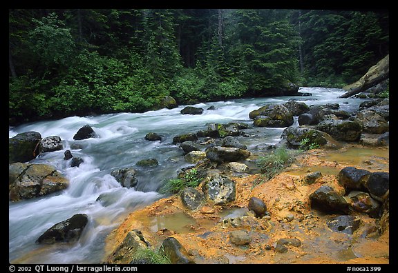
The view of Kennedy Creek near the former springs © QT Ling, terragalleria.com
Not so much a nude hike as the trail from Owl Creek to the springs is (or was) very popular this time of year. I planned to take my opportunities as they came . . . and certainly take advantage of the clothing-optional springs once I got there. And there are lots of little spur trails along the White Chuck that just cry out for some au' natural hiking and sunbathing before the afternoon wanning sun begs one to return to civilization or pitch a tent and stay the night.
I drove through Darrington from which there are two possible approaches to Kennedy. I chose the southerly section of the Mountain Loop Highway (gravel road really) because of the scenery along this stretch. I really didn't pay much attention to the signs as I'd been this route before. Nor did I bother to GPS it which I wish I had now. About ten miles into the wilderness the road ENDED!!!! Nada, nothing. Just some concrete barriers across the road and a chasm beyond! There were no detours . . . no alternatives. Used to be you could drive all the way around and end up back in Darrington.
Actually, I must have looked pretty stupid stand there beside my open car door scratching my head. Campers had set up a semi-permanent looking camp beside the river . . . decrepit motor home, blue tarps, all the accouterments of home set up, including a gas-fired BBQ. Looked like they planned to stay awhile so I walked on over. My car wasn't blocking anything sitting in the middle of the gravel road . . . there was nowhere in front of it to go.
Not a bad bunch. Fishermen and beer drinkers and they were having a great time. I asked them about the washout and I guess we've paid the price of last years winter storms. The money isn't there in the budget and there was just so much trail and forest service road damage. My only choice was to go all the way back to Darrington and try my luck from there. No . . . they didn't know if I would encounter another washout of the northern section of the Mountain Loop. I wished them good luck with the fish and turned my good ole' dusty Civic back around . . . pushing my luck here . . . this adds hours to the trip.
I decided not to tempt fate and stopped by the Darrington Ranger Station once there. Being Labor day it was closed but there is some information on the district maps outside. Here's what I learned:
The north route is still open and drivable. So is Owl Creek. But in October, 2003 when six inches of rain inundated Darrington overnight, both the White Chuck River and Kennedy Creek flooded. As those who have been to Kennedy know, the springs sit at the confluence of these waterways and there is not much of a barrier should either jump its' banks. That day, both of them did in a raging, course-changing torrent of timber, rocks and mud. Kennedy Hot Springs was right in the way and it now sits at the bottom of yards of mud. There is no visible evidence it ever existed. According to another trail seeker, there are absolutely no plans to resurrect the springs (budget woes).
Kennedy is a favorite for the foot-weary Pacific Crest hikers and as I drove back to Seattle late in the afternoon I felt cheated and depressed. Where is all my wilderness going? Does anyone care?
How to get to Kennedy Hot Springs . . . or Directions That Don't Mean Much Anymore
From Darrington drive southeast on the Mountain Loop Highway nine miles, jump chasm of washed out road, then turn left onto Forest Service Road No. 23 (also known as the White Chuck River Road). Drive 10 miles to the end of the road and the parking area for the White Chuck River Trail, elevation 2,300 feet.
Trail detail
The White Chuck River Trail (No. 643) heads east into the valley along the north side of the river before beginning a gentle uphill climb. In about a half-mile, the trail climbs and begins a long traverse toward the Kennedy Creek Basin. Near the two-mile point, Pumice Creek is crossed. This also is an area where you may encounter mudslide or avalanche debris.
A half-mile beyond Pumice Creek another slide area is encountered on a steep slope with the river below. The final three miles are generally easier as the trail enters Kennedy Creek Basin where the flooding sediment buried everything.
The trail crosses a tributary of the White Chuck River and crosses Kennedy Creek to reach the ranger's cabin (unknown if it is still there) and several nearby campsites. Back over the White Chuck River and slightly upstream is where the hot springs used to be.
If anyone has any photos of the springs themselves I would love to obtain a copy for my collection and nostalgia. You may email them to me at banged_up_shins@yahoo.com


|